
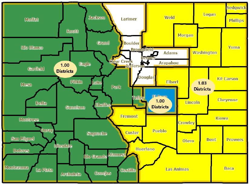
Club 20, Action 22, and Pro 15 have worked together to create the Congressional districting proposal map above. Rural Coloradans deserve voices in Washington D.C. and we need your help! Don’t let rural Colorado get left behind, to submit a comment to the redistricting commission please click below:
Click Here To Submit a Comment!
Fore more information on redistricting click here. Please see Club 20’s Redistricting letter below:
May 5, 2021
Colorado Independent Redistricting Commissions 1580 Logan St, Suite 430 Denver, CO 80203
Introduction
Every ten years our nation goes through the process of redrawing congressional districts to capture population changes over the preceding decade. The goal of good government reformers, as exemplified in Amendment Y to the Colorado constitution, is straightforward: draw districts around communities of interest that bring about the most effective representation of voters in the US Congress and to increase the number of competitive seats.
While the term “community of interest” is clearly subjective, there can be little doubt about the Western Slope of Colorado as a community of interest. It is perhaps the most clearly recognized community of interest in the entire state and should therefore be kept whole during the 2021 redistricting process. The Western Slope counties share interests on policies such as water, federal lands, forestry and wildfires, agriculture, environment, infrastructure, and outdoor recreation. This region is united by more than just geography. Our culture, economy, and way of life are uniting bonds. The redistricting process must take these considerations into account and keep the western slope in one Congressional District.
Who We Are
For nearly 70 years, Club 20 has served as the non-partisan voice for the 22 counties of western Colorado. With more than 1,000 members, our collective advocacy efforts have influenced the most impactful issues facing our region, from health care to roads and water to forests, Club 20’s mission is to advocate for the best interests of our region.
When Amendments Y and Z were in development, Club 20 was one of the first organizations to lend our support because we have experienced gerrymandering first-hand and believe in developing districts that are truly representative of the people within that district. As we have carefully considered the uniting factors that make our region so unique, Club 20 has developed a suggested map, in partnership with Action 22 and Pro 15, that keep these defining characteristics together while creating two separate and distinct rural districts. (Attachment 1)
It is with that lens that we highlight some of the critical elements that unite us as a region.
Water
Colorado was at the center of water conflicts in the Western United States even prior to statehood. In 1869 John Wesley Powell embarked on an exploration down the Colorado River to explore the homesteading capacity of the semi-arid West. Powell came back to testify before the US Senate that contemporary irrigation technology would not allow for large settlements in the West. Powell is famous for his critique that large settlements in the West are “piling up a heritage of conflict and litigation over water rights, for there is not enough water to supply the land.” Powell’s words ring true today, even with modern water management technologies.
Colorado generates over 95-million-acre feet of water annually, and about 10-million-acre feet leave the state through its borders. Of the 10-million-acre feet that leave Colorado, 82%, or 8.1-million-acre feet, exit through the Western Slope. With such a large portion of a life sustaining resource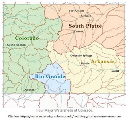 leaving the state, the Western Slope and its populace are the unofficial stewards of much of the West’s water. The choices made on the Western Slope regarding water use and management have ripple effects in numerous states downstream and even in parts of Mexico. This includes many large federal projects designed to manage and move Colorado’s share.
One of the primary considerations Club 20 evaluated when reimagining the 3rd Congressional District was our watersheds. The Colorado River Basin covers 9,830 square miles (9.4% of the total area of our state), with the headwaters beginning in Grand County. All or parts of eight counties are found within the basin (Eagle, Garfield, Grand, Gunnison, Mesa, Pitkin, Routt, and Summit), and the presence of the Colorado River directly impacts the western slope way of life. (Cite: Surface Water Resources)
Additionally, our proposed map includes the counties comprising the Rio Grande River Basin, located in the south-central portion of the state, and covering 7,543 square miles. The headwaters of the Rio Grande River begin in the eastern San Juan Mountains near the Town of Creede at approximately 12,000 feet elevation, and the river flows east into the San Luis Valley before heading directly south into New Mexico. (Cite: Surface Water Resources) Club 20 believes that the San Luis Valley should not be divided and should also be kept whole, which our map accomplishes.
The Western Slope’s vital relationship with water conservation alone is enough to designate it as a community of interest bound by the shared responsibility of stewardship. However, the Western Slope also has commonalities regarding how the region uses water. The Western Slope’s agricultural, industrial, and recreation economies rely on well-informed local representatives to protect the community’s water at the state and federal levels. To split the Western Slope in any way would compromise the unity required to properly represent water interests in the region.
Federal Lands
Not only is the Western Slope responsible for much of Colorado’s water, but our region is more than 70% of federally owned lands. In fact, some of our counties are comprised of more than 90% public lands, making their taxable property value less than 10%. The map below shows Colorado land ownership with each agency’s ownership designated by a different color. There is a clear divide between the western slope and front range communities, clearly designating western Colorado as a community with unique federal interests.
Though many of our communities do not have the tax base of their front range counterparts, they still must provide the essential services of 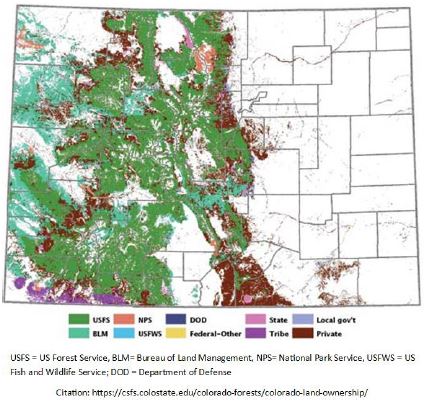 government: safe roads and bridges, law enforcement, public schools, and critical infrastructure with minimal resources. These challenges are not experienced by front range communities where virtually no federally owned lands exist.
While federal lands are preserved for the benefit of all Americans, the day-to-day responsibilities of preservation fall upon those who live closest to those lands. These lands are managed for multiple uses – from livestock grazing to energy extraction to outdoor recreation. Over generations, communities on the Western Slope have worked with federal agencies to develop and demonstrate best practices for multi-use lands for the country.
The history of land use on the Western Slope is riddled with conflict. Cattle ranchers and sheep herders who settled the state are often at conflict with contemporary needs, such as tourism, recreation, and energy development. The Western Slope has always joined together as a community to resolve these conflicts. Dividing the region would jeopardize these accomplishments and set the region back. The best way to ensure that the Western Slope’s voice and experience echo throughout the federal government is to keep the region whole during the redistricting process, not to dilute the community’s voice by combining it with urban and suburban Front Range communities with widely different interests.
Forest Health and Watershed Restoration
Colorado has more than 24.4 million acres of forestland and many of these forests include the headwaters of rivers that provide reliable, affordable water supplies which are foundational to the environment, economy, and quality of life in rural Colorado. In fact, rangeland and forest are the predominant land uses in the Colorado Basin (85%), with forested land present throughout many parts of the basin. A substantial portion of the basin is comprised of federally owned land, with livestock, grazing, recreation, and timber harvesting as the predominant uses on those lands. (Cite: Surface Water Resources)
Coming off the worst wildfire year in Colorado’s history, we know, all too well, that many of our forests are unhealthy due to poor stand conditions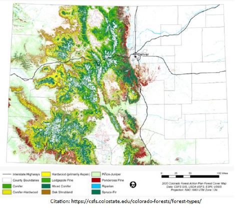 from lack of forest management, long-term droughts and warming temperatures and variability due to climate change, therefore making them susceptible to catastrophic wildfire and insect and disease epidemics. More than 3.4 million acres of Colorado’s forests have been impacted by mountain pine beetle and almost 1.8 million acres have been impacted by spruce beetle, causing wide-spread tree mortality. We also understand that healthy forests, achieved through health forest management, reduce net carbon dioxide, lessening the impacts of climate change.
Forest fires are larger and four times more frequent than before 1987 and burn at an average of six times more land per year, putting our forest headwaters and water supplies at risk. In fact, between 2002 and 2018 over 2.7 million acres have burned in Colorado, severely degrading watersheds, and costing millions in water infrastructure repairs.
The Colorado Statewide Forest Resource Assessment of 2008 has identified 642 watersheds susceptible to damaging wildfire, and 371 forested watersheds with high to very high risk from post-fire erosion, many of these watersheds, encompassing about 9.4 million acres of spruce-fir, aspen and pine forests that contain critical infrastructure for municipal drinking water supplies.
The map to the right shows an overview of forest types, ALL of which reside west of the continental divide.
Improving forest health and watershed protection are critical to the sustainability of the western slope. These attributes literally define our culture of a love for our lands while balancing the need for healthy forest management. These forest boundaries naturally create a community of interest within the west slope and should be kept together as our federal representative works with these communities to develop actionable forest management plans.
Environment
Having access to such unique and valuable resources means the added responsibility of proper stewardship. The Western Slope has a long history of unique wildlife management. Wildlife, including wild horse herds, sage grouse, and the looming threat of zebra mussel, are constant considerations for communities in the Western Slope.
Club 20 supports protection of endangered species as important to the economy and quality of life in Western Colorado and the rich variety of wildlife that inhabit the myriad of our landscapes are valued by those who live and visit our region.
Communities across western Colorado have worked together diligently to develop commonsense plans to protect these species while taking into consideration the unique geographical and topographical landscapes of the region. While endangered species know no congressional boundaries, they are bounded by geographical barriers, such as the Rocky Mountains. Managing these populations is made easier when impacted communities reside within the same congressional district.
Environmental stewardship is an everyday reality on the Western Slope; a united voice serves the community best.
Agriculture
Agricultural production is the foundation of the state of Colorado. Our heritage lies in farming and ranching.
The Western Slope has a thriving – and unique – agriculture industry. The Bureau of Land Management alone owns 7.8 million acres of land in Colorado strictly for the use of livestock grazing, most of it on the Western Slope. Despite steady population increases and growing technology industries along the Front Range, Colorado’s most valuable export is beef, accounting for over $720 million in exports per year.
Beef is not the only agricultural product of the Western Slope: fruits like peaches, apples, and grapes are staples of the economy. Peaches make up 75% of the fruit production in Colorado, and most of these peaches come from the Western Slope. The region produces over 17,000 tons of peaches per year, netting $40 million for the regional economy. Over 90% of the grapes grown in Colorado come from the Western Slope, which also ultimately fuels the 400,000+ gallons of wine produced in Colorado each year.
Our region’s agriculture economy is facing numerous threats including wolf introduction, endangered species management, diminishing water supply, issues with grazing allotments, volatile commodity prices, ever-changing trade agreements, and utilization of migrant farm workers just to name a few. As Club 20 evaluated the communities of interest, the agriculture community immediately stands out as possessing unique challenges and opportunities and should not be divided.
Infrastructure
Whether it is water use, land management, or agriculture, how we interact with the land is at the core of what makes the Western Slope a united community. Infrastructure development is no different. Whether discussing transportation, telecommunications, utilities, or power distribution, the story is the same: everything is more challenging on the Western Slope. Transportation here has unique challenges, ranging from geography to weather. With only one major interstate traveling through the center of the region, many areas have only narrow and dangerous highways to move commerce. If landslides, wildfires, or snowstorms do not close roads, continuous mitigation projects are slowing traffic and the movement of goods through
the region. While much of the Front Range develops infrastructure around a growing population, the Western Slope must still consider nature and geography to maintain and evolve its transportation infrastructure.
Utilities and telecommunications also have unique challenges in developing and implementing services for rural communities in the region. Digging and laying infrastructure for fiber, gas, and electricity on the Western Slope means grappling with long distances between communities, long distances from major transportation corridors, and the varied geography of mountainous communities.
Tourism and Recreation
The tourism and outdoor recreation sector are a major contributor to the Western Slope economy. The area’s natural and rugged landscape have always attracted residents and tourists alike. Mountains, valleys, rivers, and lakes generate recreation, as do the three largest national forests on the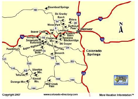 Western Slope. When combined, the Grand Mesa, Uncompahgre, and Gunnison National Forests pump over $445.9 million into the region’s economy each year – and that’s just from tourism alone. This amounts to over 5,800 full time jobs for Western Slope residents and almost $80 million in wages per year, just one example of the economic benefits provided by outdoor recreation and tourism to the region. Northwest Colorado boasts some of the best hunting and fishing opportunities in the nation, bringing in hunters and anglers from across the nation.
Though it goes without saying, most of Colorado’s ski resorts are found on the western slope, as referenced by the above map. These communities have unique needs, priorities and challenges ranging from mitigating climate impacts to providing affordable housing for their workforce. When Club 20 developed our attached map, we endeavored to keep these communities together to the maximum extent possible while meeting the population requirements to make a whole district. We feel that our map achieves this balance.
Whether it is fishing, hunting, hiking, snowmobiling, or just enjoying our historic towns with a glass of wine, outdoor recreation is central to the Western Slope experience and many who visit our region make their stay permeant by becoming west slope residents. These communities of interest should remain together, rather than being placed in a district with metro Denver to avoid having their voices diluted by the more populous parts of the district.
Conclusion
As we have carefully considered the uniting factors that make our region so unique, we have not considered the political ramifications of the map we are proposing. This is intentional. It is not Club 20’s charge to propose a map that benefits one political party over the other, but rather, to keep our region’s interests, economies, and watersheds intact as we work together to advance our region on state and federal issues.
While the term Western Slope denotes geography, it encompasses so much more. The Western Slope has unique challenges and opportunities, distinct rural and urban cultural differences, and a slew of federal concerns and clearly define the region as a community of interest. We deserve our own voice, as one united congressional district.
From the responsibilities incumbent upon the region relating to water and public land stewardship to the struggles of infrastructure improvement, the Western Slope is a community bound by experience as much as it is by the rivers and mountains that physically connect it. To fracture the Western Slope would be a disservice to a community that has for generations worked to resolve conflict, overcome adversity, and create its own way of life. The Western Slope is united not because of political boundaries but despite them. Even as members of Congress change in person and in party, the unity of the Western Slope in one congressional district allows us to seek the best representation from a single member of Congress.
When you think “Colorado”, you immediate think of the rivers, mountains, and that stubborn Colorado spirit that has differentiated our state for decades. We know how to do this right.
We urge you to consider our proposed map and make the Western Slope whole in one congressional district during this redistricting process.
Respectfully,
Christian Reece
Executive Director
Club 20